Wall Mile 55

Wall Mile 55 [HB 328]

The Wall leaves the eastern end of Walton and heads downhill, the ditch being clearly visible from the lane along which the National Trail passes (as does more than a little traffic, it should be noted, so care is advisable).

Ditch in the field

Ditch in the field

Before crossing Dovecote Bridge, we may look through the gate to our left and see an English Heritage sign for a section of consolidated curtain wall that was formerly visible here during the summer months (being covered with straw and buried during the winter). Unfortunately, despite these precautions, the soft red sandstone weathered badly and the section had to be permanently buried. It would have been the westernmost portion of consolidated curtain wall, but now it is not. We have to wait a while for that pleasure.

Reburied Wall

Reburied Wall

Crossing the bridge, the Trail originally followed the Wall across country, but for several years now there has been diversion in place that forces the murophiliac to stick to the road and risk the traffic for a while longer. Climbing from the valley, the road bends round to the left and, finally, a sign to the right directs us once more onto the course of the wall, still marked by hedgerows and fence lines. Following the Trail, before we get to the first stile, we pass the site of Milecastle 55.

Wall Mile 55 from the air

Wall Mile 55 from the air

Milecastle 55 (Low Wall) [HB 328; haiku]

The position of Milecastle 55 (Low Wall) was confirmed by excavation in 1900. An altar to Cocidius was found at Howgill in the 18th century, not far away, so may well have originated in the milecastle (as others have done).

PLVad2

Wall Mile 56

Wall Mile 56 [HB 328–9]

Proceeding east from Cambeckhill Farm, the ditch can just be distinguished as a slight depression, whilst the line of the curtain wall is indicated by a modern fence to the south of the Trail.

Looking towards the Cam Beck

Looking towards the Cam Beck

Castlesteads

To your south, amongst the trees on the high ground beyond the Cam Beck (a tributary of the Irthing), lies the site of Castlesteads (Camboglanna), one of the detached forts immediately south of the Wall (the others being Carvoran, Vindolanda, and – probably – Newcastle). Neither Carvoran nor Vindolanda were within the Vallum, but it makes a very deliberate detour in order to include Castlesteads. The fort lies 12.8km (8.0 miles) east of Stanwix and occupies about 1.5ha (3.7 acres: an informed guess, since the western defences have been eroded by the river). The site is on private land and has effectively been razed by the formal garden of a late-18th-century listed building, Castlesteads, constructed on the site of an earlier Walton House belonging to the Dacre family. No trace of the fort is visible from the air, although the civil settlement has been detected by geophysical survey and the fort itself was summarily trenched in 1934, allowing the extent of its defences to be defined and the fact that the stone fort was preceded by a turf-and-timber one to be determined. However, even if you could see it, there is little to see.

The site of Castlesteads fort from the air

The site of Castlesteads fort from the air

Inscriptions reveal that the units based here included the part-mounted cohors II Tungrorum and cohors IV Gallorum (who were also to be found at Vindolanda). The Notitia Dignitatum omits the garrison of Camboglanna whilst mentioning the fort, possibly a scribal error. Old Ordnance Survey maps equated Castlesteads with Uxelodunum, all part of the confusion caused by thinking the well-preserved Watch Cross camp (now under Carlisle Airport) was a fort.

The ditch running up from the Cam Beck to Sandysike

The ditch running up from the Cam Beck to Sandysike

Back on the National Trail, before long we reach the wooded valley of the Cam Beck itself, a small wooded gorge that almost certainly had to be crossed by the Wall, just as the Trail now crosses it, by means of a bridge. Once over the far side, the line of the ditch climbing up towards Sandysike is very prominent, although near the top the Trail takes a detour off to the north alongside Swainsteads, before heading south again towards Sandysike itself. We dive into woodland and emerge to cross a small burn, another tributary of the Irthing, before climbing up the hill towards Walton. Here, uncharacteristically, the line of the Wall is to the north of us, crossing open ground, and the field boundary immediately to our south has nothing to do with it. Finally, we emerge into the western outskirts of Walton, where the measured site of Milecastle 56 is assumed to be, although another minor road must be crossed before we can proceed.

Milecastle 56 (Walton) [HB 328; haiku]

The site of Milecastle 56?

The site of Milecastle 56?

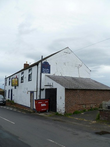
Milecastle 56 (Walton) is assumed to lie beneath the now-defunct Centurion Inn (which boasts an amusing cod-Latin date on its western gable end) but no trace of it has ever been found.

Wall Mile 57

Wall Mile 57 [HB 335]

We follow the road along until we reach the main road from Brampton to Longtown at Newtown and we are obliged to cross it with the utmost caution. Once over, we follow the signs that take us on an unusual journey right into a farmyard, then rapidly left then right behind a low wall, and then left again, depositing us rather unexpectedly into somebody’s garden, through which the Trail passes. Veg looks good! Onward and we are once more in open countryside, the merest hint of a depression to the left indicating the line of the ditch.

Water in the ditch

Water in the ditch

Before us is the stables at Heads Wood, usually guarded by rather magnificent horse in the paddock we have to cross. To the right, at the edge of an escarpment, is a set of stone-flagged steps leading down to the flood plain of the Cam Beck. As we pass down these, the ditch is to our left and we can see the hedgerow betraying the line of the wall in front of us. The Trail leads us around the north side of Beck Farm, built out of red sandstone, mostly salvaged from the curtain wall, and finally round to cross the stream which gives the farm its name, then on to the next farm, with the ditch now to our right and the hedge within it.

Beck Farm

Beck Farm

Looking to our right, beyond the hedge, we can see the woodland covering the south side of the Cam Beck valley, cloaking the site of Castlesteads fort above it. Passing on, through the farmyard of Cambeckhill, we arrive at the presumed site of Milecastle 57 (Cambeckhill).

The hedge is now in the ditch

The hedge is now in the ditch

Milecastle 57 (Cambeckhill) [HB 334–5; haiku]

In common with so many of the western milecastles, nothing of this one has been found, but by distance it should be beneath the farm buildings.

CGHad

Wall Mile 58

Wall Mile 58 [HB 335–6]

The Trail continues on this track for a short distance before breaking out into slightly more open country. All trace of the curtain wall line disappears, but the ditch remains to our left. We round a corner, a change in alignment almost due north-east, and soon the Trail crosses into the now completely ploughed-out ditch for a while, the fence line marking its northern lip.

Ditch to the left, near the Wall line

Ditch to the left, near the Wall line

Then, just for a change, as we approach the top of a gentle incline, the Trail crosses over to the north berm before we burst into the rural haven that is the outskirts of Newtown. Crossing the road carefully, we keep to the right-hand side and pass through the village. The line of the curtain wall and ditch is to the south of us until we reach the site of Milecastle 58 (Newtown).

The Trail enters the ditch

The Trail enters the ditch

Milecastle 58 (Newtown) [HB 335; haiku]

The measured position of the milecastle itself is set back from the road and has not been located, so not only is there nothing to see, we don’t even know where it is in order not to see it!

Site of Milecastle 58

Site of Milecastle 58

Wall Mile 59

Wall Mile 59 [HB 336]

The course of the ditch is still readily apparent whilst the curtain wall itself is once again marked by the hedgerow. About 1.5km to the south, partly beneath runway 07 at Carlisle Airport, lies Watch Cross (sometimes known as Watchclose) temporary camp, right next to the line of the Stanegate. This was so prominent in the 18th and 19th centuries that it was thought that it must be a Wall fort and so it was included by Horsley in the listing of fort names as Aballava. Sadly, excavation in 1935 showed it to be only a temporary camp, but even before then scholars had dismissed the notion as fanciful and all the fort names had been reshuffled.

Old Wall

Old Wall

Before very long, Old Wall appears on the far side of a minor road. The older buildings on the farm are, of course, built from Wall stones, as is the revetment for the small ditch to the right of the path.

Walking on the berm

Walking on the berm

Continuing eastwards, the Wall turns almost due east for a while and we embark upon another section of walking on the berm, passing gently uphill along a track, with the line of the curtain wall to our right, and the ditch to our left (although we are separated from the last by another hedgeline). Near the peak, we pass the site of Milecastle 59.

Milecastle 59 (Old Wall) [HB 336; haiku]

Site of Milecastle 59

Site of Milecastle 59

Milecastle 59 (Old Wall) was apparently excavated by Hodgson in 1894, who found fragmentary remains and pottery, and one wall has subsequently been located by geophysical survey in 1980/1.

The PLV ebooks

Wall Mile 60

Wall Mile 60 [HB 336]

Just after Wall Head, the lane along which we have been walking turns off to the right, but we are going to follow the line of the Wall straight on and through a gate and one of the many benefits of walking Hadrian’s Wall west to east suddenly becomes apparent.

Track on line of Wall heading towards Blaetarn

Track on line of Wall heading towards Blaetarn

Here, for the first time, the Wall ceases to coyly peep at us from hedgerows and the major components – or at least their respective remnants – present themselves. The line of the curtain wall itself is represented by a low causeway running across the pasture towards the farm at Bleatarn, whilst a depression to the left marks the course of the ditch and, some way to the right, the earthworks of the Vallum can be made out near the western field boundary. Aerial photography has revealed extensive pre-Roman field systems in this area, the alignments of which the Wall blithely ignores (later agriculture always tends to respect the monument, which is why its course is so obvious across most of the countryside).

Causeway leading to Blaetarn

Causeway leading to Blaetarn

As we move along our mural causeway towards Bleatarn Farm, it will become apparent that some substantial earthworks, possibly associated with hollow ways and quarries, have enhanced and in part removed the line of the ditch to the north, whilst next to the farmhouse itself, the rather pleasant rush-bedecked tarn which gives it its name is probably also a result of such delvings.

The Trail crosses a lane by means of two gates (through the first you need to look slightly to your left to find the second), and then we are in the fields again. To your right, next to Bleatarn Farm, you will find one of the few portaloos provided along the line of the trail. If the National Trail has failings (it actually has several), one of the most serious is the lack of provision of facilities for walkers. Later we will encounter grumpy notices asking us to refrain from using farm buildings as lavatories, but what we seldom find are such thoughtfully provided toilets as this one at Bleatarn. This subject is by and large avoided in most discussion of the Trail and why this should be is mystifying.

Hollow way on the line of the Wall ditch

Hollow way on the line of the Wall ditch

Crossing the field, we keep immediately north of the hedgerow, noting how the line of the ditch to our left is used by a green lane. Once we have crossed the next field boundary and are in the second field, we are close to the site of Milecastle 60. Looking back, we can see how we have been walking along the berm (the hedgeline in the next field to the east takes up the line of the curtain wall itself again) and that the green lane has moved up onto the north lip of the ditch, which is now decidedly sodden.

Congratulations – together we have completed twenty Roman miles of the length of Hadrian’s Wall, or exactly one quarter of its original length (but not, please note, one quarter of the length of the National Trail – they are two very different things).

Milecastle 60 (High Strand) [HB 336; haiku]

The site of Milecastle 60

The site of Milecastle 60

Although Milecastle 60 (High Strand) has never been excavated, the site has provided another altar to Cocidius, only five Roman miles after the last one, hinting at the popularity of this deity on the western side of the Wall.