Wall Mile 35

Wall Mile 35 [HB 228–31]

The curtain wall, beneath the by-now-familiar field wall, descends into Busy Gap and is breached by a modern gateway called the King’s Wicket which seems to have a history. Busy Gap was a traditional route through the wall in the medieval and post-medieval period, ne’er-do-wells who used it for their nefarious activities earning the nickname Busy Gap Rogues (a term of abuse that remained in use into the 19th century). It has an even older significance, however, as an earthwork dyke that may date as far back as the Bronze Age runs through the gap and on towards what is now Scotland. Once again, the Roman Wall merrily slices across a traditional landscape. The angle between the wall and the dyke is adapted into a triangular enclosure by the earthwork known as Black Dyke, here thought to be used as a post-medieval stock enclosure associated with the passage through the wall. The Wall ditch reappears across Busy Gap, recognising its tactical vulnerability but terminates again once it begins to ascend Sewingshields Crags.

Looking towards Sewingshields Crags

Looking towards Sewingshields Crags

We follow the wall up, passing the site of Turret 35b and, once we achieve the summit, can pause to look back to the west, where we can see Broomlee Lough, Greenlee Lough beyond it, and Housesteads Crags, with Crag Lough and Peel Crags in the distance. At the top, a short length of curtain wall emerges from underneath its guardian field wall, just to remind you of its existence.

The curtain wall on Sewingshields Crags

The curtain wall on Sewingshields Crags

Before long we stumble unexpectedly on Turret 35a (Sewingshields). Constructed on a broad gauge foundation but with a narrow gauge curtain wall, this turret, with its entrance at the eastern end of the south wall, was only briefly occupied before being demolished and its recess filled in.

Turret 35a

Turret 35a

The next stretch of curtain wall we find has a rather nicely consolidated expansion near its eastern end, confirming that these were not just a product of the imagination of Clayton’s workman but were a genuine feature of the south face of the curtain wall, along the Central Sector at least.

Moving on we encounter further spasmodic sections of curtain wall bursting out of the turf and before too long we reach another trig point, which is a good place to consider King Arthur. Who? Why? Well, remember King Arthur’s Well in Wall Mile 44? Tradition (although not a very old one, truth be told) has it that he and his sleeping knights lie nearby, waiting for the call to defend Britain once again. Having dozed through sundry national threats (the Armada, Napoleon, for example) he was supposedly disturbed from his slumbers by a Northumbrian shepherd in pursuit of a ball of twine (string-related mishaps being common among northern stocksmen). This has little relevance to Hadrian’s Wall, other than to show how it has acted as a focus for myth formation as much as any other human activity (but most notably stone robbing), and Arthur is both ubiquitous and ‘sticky’, as well as beloved of tourist authorities the length and breadth of the land.

More stretches of curtain wall lead us to the site of Milecastle 35, clinging on to the edge of Sewingshields Crags by its fingertips.

Milecastle 35 (Sewingshields) [HB 228–30; haiku]

Milecastle 35

Milecastle 35

Milecastle 35 (Sewingshields) was excavated in 1978–82 and the first thing the visitor notes is that this long-axis milecastle has no north gate. This is one of those few instances where it would be truly superfluous. The interior of the fortification is occupied by several phases of Roman building on either side of the central roadway, culminating in its re-use as a medieval farmstead. The later Roman phases included evidence of metalworking on the site.

The PLV ebooks

Wall Mile 36

Wall Mile 36 [HB 231–50]

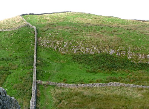
Leaving Milecastle 37, we head east towards the plantation and a rare treat: the only chance to actually walk on the wall. Once upon a time, walkers merrily yomped along the top of the curtain wall in the central sector without giving much thought to the damage they were doing. Increases in visitor numbers mean such access has had to be limited to one carefully controlled section, here in the woods immediately west of Housesteads fort. It should be pointed out that the drop to the north is a bit hairy, so the vertiginously inclined can walk on a path immediately to the south of the curtain wall. There is a popular climbing pitch along here and occasionally richly accoutred climbers will pop up whilst you are heading along the top. Smile benignly at them and pass on.

Before long, we exit the plantation and a gate on the right takes you down past the fort to pay for a ticket at the small museum to examine Housesteads itself, whilst the Trail itself rather grumpily lurches to the left and would take you along the northern wall of the fort and down a rather steep and badly eroded slope without a chance of a peek at this most impressive of forts. The museum has a small display about the site and some of the finds, as well as a bijou shopportunity.

Housesteads from the air

Housesteads from the air

Housesteads fort (VERCOVICIVM)

By dint of visitor numbers alone, Housesteads is the best-known and most popular Roman fort in Britain. For many, it is Hadrian’s Wall. It lies 9.7km (6 miles) beyond its neighbour, Great Chesters, but only 3.2km (2 miles) from the Stanegate fort of Vindolanda (the older name for which, Chesterholm, is seldom used now). Housesteads is another fort that is oriented east to west, in this case in order to fit it into the limited available space at the end of the dolerite ridge above the gap through which the Knag Burn flows. As it is, it occupies 2ha (5 acres) and still slopes quite considerably inside.
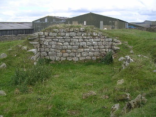
A water tank

A water tank

There was no ready source of fresh water within the fort, although there is the Knag Burn down the hill which supplied the bath-house down there. Therefore, quite unusually for a British fort and more in keeping with its cousins in Jordan or Syria, Housesteads was dependent upon the collection of run-off from roofs and road surfaces, so great attention was paid to the provision of water tanks. This in turn allowed the flushing of the latrine building in the south-east corner of the fort.

The garrison was the cohors I Tungrorum milliaria (about 800 infantrymen), which moved there from Vindolanda (the Tungri originated west of the Rhine, around the Ardennes). It was later supplemented by a cuneus Frisiorum and the numerus Hnaudifridi, both quite clearly Germanic in origin. The depiction of an archer on a sculpted panel from Housesteads (now in the Great North Museum, so we can see it later) has led to the suggestion that a detachment of cohors I Hamiorum (who we know were based in the Stanegate fort of Carvoran) may have been based there at some point (and they came from Hamah in Syria).

SW corner of Housesteads

SW corner of Housesteads

From the museum, we can make our way to the entrance to the fort (which will soon revert to the south gate, after many years of being through a gap in the south wall near the south-west corner), but should pause briefly on the way to look at the exterior of the south-west corner, noting the Crunchie-bar-shaped blocks of stone that were used to repair it in the late Roman period.

South gate at Housesteads

South gate at Housesteads

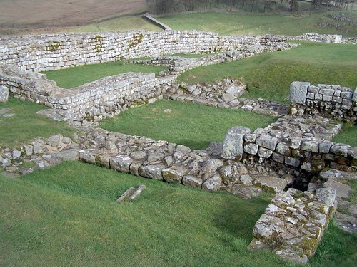
Duly enlightened, we can now proceed to the south gate. The first thing to note about this double-portalled gateway is that it has been adapted and the east tower has acquired an additional structure, since this was a fortified medieval farm, notorious in its day for the unruly nature of its inhabitants, as well as a corn dryer in its eastern tower. The south gate itself, you will not be surprised to learn, had its east portal blocked (and the blocking removed by 19th-century excavators). The central pier (or spina) between the portals contains two fine examples of pivot holes for the gates, each with channels to allow the gate leaf to be fitted. Looking up the hill from the gate, we are looking along the via principalis (the main short-axis street) from the porta principalis recta (or south gate) towards the porta principalis sinistra (or north gate, which we can’t actually see because of the shape of the hill). So now it is time to go exploring the central range, since this is the first fort we have encountered that will let us examine all three principal components.

The CO's house

The CO’s house

First, on our left-hand side, we see the commanding officer’s house (praetorium). Although it conforms to the Mediterranean-style, high-status courtyard dwelling, it is a radically unusual example: the awkward terrain has forced its builders to terrace it into the hillside. The south-eastern corner contained a stable, whilst the east and west wings climb up the slope to the north wing, which is considerably higher than the south and has been taken to imply a second storey at the lower level (thereby pre-empting the medieval Borderers’ habit of living above their animals). The courtyard in the centre is worth a look, as it has been paved in a late phase with Crunchie-bar-shaped blocks and even bits of window head (monolithic blocks with a semi-circular cut-out, imitating an arch, that acted as lintels above window openings): heritage hardcore as crazy paving. The north range has a series of rooms with underfloor heating, something of a prerequisite for this area in a winter, but actually a common feature in commanding officers’ houses everywhere. The commander and his familia (his slaves being included within that term) lived and worked within those four ranges of rooms, socially delineated, functionally adapted, and decidedly terraced.

The HQ building

The HQ building

Now we move uphill to the principia or headquarters building, a fine example of its kind. Entering from the main north to south street (the via principalis, if you recall), we encounter the first of the three components of this building: the courtyard. Open to the elements, but surrounded by a peristyle, it harked back to the days when the centre of a Roman camp was its forum, where the soldiers could assemble. The Romans had no gutters on roofs, so there was an eavesdrip round the courtyard which channelled the run-off into the drainage system. Moving westwards, we proceed into the cross-hall, a high covered structure with additional entrances at each end (to our left and right). To our right is the raised podium or tribunal (yes, that’s where we get the English word from) from which the commander could address his troops or, more likely, his centurions at the daily morning briefing (for which we have documentary evidence from other sites), when the daily password was set and unit statistics passed on. In front of us is the rear range of offices, with the shrine of the standards, the aedes principiorum, directly in front of us. Remember, this is placed so that it is visible from the porta praetoria, in this case behind us, to the east. Offices on either side of the aedes contained the clerks who handled unit administration and looked after the records.

The hospital

The hospital

Immediately to the west of the headquarters building is an additional courtyard structure. Since another house seemed unlikely, the excavators decided this must have been a valetudinarium or hospital. All forts had them (the example at Vindolanda is mentioned in the famous writing tablets) so it is not an unreasonable deduction, although the evidence (similarity with other, larger, such structures) is circumstantial, rather than conclusive (like, say, a lopped-off limb or two or a set of medical implements). Rooms were arranged on four sides around a courtyard, one of them suggested as an operating theatre (it is bigger than the others), and with a latrine incorporated in the south-west corner of the structure.

North granary

North granary

The fort had two granaries, to the north of the HQ, but they are rather unusual, since it has been suggested they may originally have constituted one large structure. A central row of column bases, subsequently concealed between the north wall of the south granary, and the south one of its northern neighbour, are one clue, whilst those two butted partitions, inserted between the end walls, are another. If we stand at the west end of the northern granary, in its doorway, there are a number of useful things we can note. To the east is the interior, with its floor (long gone now) raised on small stone columns or pilae; these, together with the ventilator slots in the side walls, allowed air to circulate beneath the floor to keep the contents cool and (it is always said) discourage (but not necessarily completely defeat) vermin. The threshold upon which we are standing is in fact a loading platform, against which carts could be backed up, so that gives us a good idea of street level here in the Roman period. Looking down, you can see that sockets and openings reveal that there were once two inward-opening doors here. If feeling energetic, we can nip round to the south side of the south granary to see more evidence of the adaptation of this fort building into a medieval farm: another corn dryer in the middle of it.

Turret 36b foundations

Turret 36b foundations

Just north of the granaries, beyond another store building squeezed into the available space, we find the remains of Turret 36b, demolished (along with a stretch of Hadrian’s Wall) once it was decided to construct Housesteads. The north wall of the fort was pushed further north, right to the lip of the slope, to gain as much room as possible, hence the need to level the existing curtain wall.

The north gate

The north gate

The north gate now has an imposing drop below its external threshold, but this is a result of a causeway having been removed during the 19th-century excavations. We can stand near the edge and look at the usual attributes of a gateway, most notably marking-out lines which facilitate the placing of the massive opus quadratum blocks of the gate piers and jambs.

Between the north gate and the north-east corner, the Romans suffered repeated problems with the stability of the wall now that it was placed nearer the edge of the slope. This was compounded by the habit of removing the rampart to insert rampart-back buildings like workshops, then demolishing them and putting the rampart back! Anyway, several collapses later, they started reinforcing the back of the much-abused rampart, the back of which (marked now by lines of kerb stones) crept ever further across the road towards the barrack. What started out with room to drive a cart along ended up barely wide enough for a single person to get through. Excavations showed those workshops were busy working with leather (mainly cobbling, since the water tanks ended up full of old shoes, betrayed by their hobnails), blacksmithing, and casting copper-alloy equipment.

Things had also gone a bit wrong at the north-east corner of the fort at a very early stage. Placing the angle tower in the correct position meant, inconveniently, that it was not at the junction with Hadrian’s Wall itself (one wonders at which point this was noticed!), so that was demolished and a new tower placed slightly to the west of it. This speaks volumes about how the whole story of the Wall was one of adaptation (or fudge, the unkind might observe).
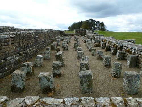
Barrack XIII

Barrack XIII

Two barrack buildings, XIII and XIV, have been consolidated in their late ‘chalet’ form, with each contubernium in the form of a separate hut, but more standard long barracks were located beneath them and some of the walls were reused in the later versions. The officers’ buildings were at the east end of the buildings and one of them contained a piece of a hackamore from a horse harness. Next to Barrack XIV, to the south, was Building XV, originally a storehouse and later adapted to contain a small bath-house. Note those Crunchie-bar-shaped stones used in its reconstruction. East of the two barracks is a late interval tower, but that is perched (rather precariously) on top of a larger Hadrianic bakehouse that was found to contain two circular bread ovens (which you can no longer see), presumably one for each barrack.

The east gate

The east gate

The east gate has a potent piece of folk mythology associated with it, the ruts in the threshold block supposedly influencing the Standard Gauge of 4ft 8½in (1.435m) adopted by Stephenson for his railways. The debunking of this myth is done with the aid of horses’ bottoms (naturally). The axle width of a cart is dictated by the need to comfortably fit a horse into the poles; hence modern carts resemble Roman carts in a lot of details, including axle width. Since railways evolved out of the horse-drawn waggonway carts that hauled coal along Tyneside from mine to staithe, also one horse’s width, we have our equally interesting, but less romantic, answer: it’s a coincidence.

Moving on downhill, we see the remains of an ascensus or stairway to the south of the east gate. This is one of the means by which soldiers got onto the rampart walkway. Next there is another interval tower before we reach the heavily modified south-east corner tower and its attendant facilities.
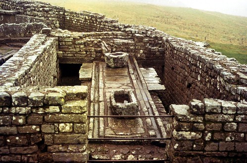
The latrine

The latrine

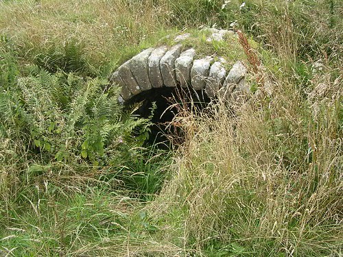
This corner provides everybody’s favourite bit of Housesteads: the latrine. This much-sniggered over piece of functional engineering was flushed by water held on the large header tank with the scalloped edges, the water passing clockwise around the inner channel so that soldiers’ sponge sticks could be rinsed, and then anti-clockwise around the sewer beneath the seating space, finally debouching through an arched outlet straight into the civil settlement. Property prices in that area were probably rock-bottom.

The sewer outfall

The sewer outfall

The scalloping around the tank has caused some comment, it often being suggested that this was caused by soldiers sharpening blades (unlikely, since hones, found by the dozen in the fort, were a much more efficient way of doing that). It may instead have been caused by washing clothes, the slight downward trend of the ‘scallops’ being a possible indication of this. Like much of life, if you have to sum up Hadrian’s Wall (and certainly Housesteads), you can probably do it with this latrine.

North pier of west gate

North pier of west gate

Now, how keen are you on gates? For the sake of completeness, you should see the splendid west gate on the far side of the fort but we shall be understanding if you decided to skip this part of the tour; we can leave you sitting morosely on part of the site (assuming it’s not raining, which it does quite a lot at Housesteads). Two portals again, both ultimately blocked (the northern first, it is suggested), and the north pier surviving to the height of the arch springer. Slots can still be found to secure the gates, as can the usual sockets, threshold blocks, and more marking-out lines.

'Murder House' in the civil settlement

‘Murder House’ in the civil settlement

Outside the fort are some of the vicus buildings. Next to the south gate is the House of the Beneficarius [sic] (yes, there were even spelling errors on old Ministry of Works signs), and further down the hill is the inspiringly named Murder House (you’ll never guess what happened there: two Roman bodies under a newly laid floor, one with the tip of a blade between the ribs). Don’t make the mistake of thinking the circular well enclosure is Roman; that belongs to Housesteads’ long history as a farmstead, rather than a Roman fascination with building circular structures with no apparent entrance.

We can usefully resume our journey by passing round the outside of the south-east corner of the fort and making our way diagonally down the slope towards where the curtain wall crosses the Knag Burn. As we go, examine the outer face of the fort wall and see more long blocks typical of late rebuilding: this is one heavily patched fort!

The valley of the Knag Burn was not only the site of the bath-house for Housesteads (no longer visible) but also a gateway through the Wall.

The Knag Burn gateway

The Knag Burn gateway

Knag Burn Gateway, thought to have been built during the 4th century and examined in the mid-19th century, consists of two towers, one on either side of a single portal. As such, it is not particularly noteworthy, but it does give us a clue what the gateways on Roman roads at Carlisle, Portgate, and (possibly) Newcastle looked like. This, however, is not on a major road, but rather a minor route, perhaps a pre-existing transhumance route. Interestingly, there were two sets of pivot holes and it has been suggested that two sets of gates were in use at the same time. Clearly, there may have been other gates along the Wall which have not as yet been found.

Looking back towards Housesteads

Looking back towards Housesteads

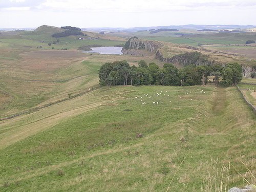
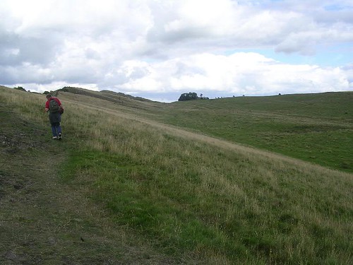
The Trail now leads us on into an angle in two field walls where a stile takes us over and into another plantation. A short length of ditch survives to the north-west of the plantation but has not been identified over the rest of the Knag Burn valley, although it might have been anticipated. Out the other side and we are now yet again following a field wall to our left that is on top of the curtain wall. The ditch stops as we ascend Kennel Crags but the Military Way is still with us to the south. Further down the dip slope is the Vallum, die-straight as ever. We climb a small hill, descend into another gap, then climb higher to a small plateau, King’s Hill, where we find our next milecastle.

Milecastle 36 (King’s Hill) [HB 231–2; haiku]

Milecastle 36 (King’s Hill) was a long-axis example perched on a hill, overlooking Busy Gap to the north-east. The identity of the king in question will become clearer once we get up onto Sewingshields Crags in a short while.

Wall Mile 37

Wall Mile 37 [HB 250–5]

As soon as we have finished with Milecastle 38 we have an invigorating climb up to Hotbank Crags. There are almost permanent problems with erosion up here so try not to tread on eroded areas (remember that grass is very resilient until it is worn down to its roots and then it becomes vulnerable). It is one of those hills that just keeps on giving (or taking, depending upon your point of view) and whilst the hardy will stick to the curtain wall, the less resolute can branch off just past the hexagonal plantation and rejoin the less-demanding Military Way. The ditch is rendered unnecessary again along the crags, whilst further down the dip slope the Vallum is gradually converging with the course of the curtain wall.

Cuddy's Crags

Cuddy’s Crags

Once we reach the top and have caught our breath, the going is easier again and we barely notice as the Claytonized wall gives way to a modern drystone wall, which then descends into Rapishaw Gap, this time being pierced by a gateway that marks the line of the Pennine Way. Crossing a stile, we are confronted with a prominent outcrop, on top of which is the neatly terminated end of another stretch of Claytonized curtain wall. The easiest way round this is to head south for a short way and then almost double back to get up to the line of the wall itself, so that we are only climbing easy inclines and not risking life and limb scrambling up rocks. The timid can take the opportunity to carry on along the line of the Military Way, but to do so will involve missing another of those iconic views. Back on the crags, the Trail takes us 180m along Cuddy’s Crags to another re-entrant (with ditch, naturally) that suddenly presents us with the most famous prospect of Hadrian’s Wall: the gap between Cuddy’s Crags and Housesteads Crags with Housesteads Plantation perched on the edge of the precipice. It is highly unlikely that you have never seen this view somewhere, whether it be on a poster, postcard, or book cover. One of the earliest versions was a postcard produced at the beginning of the 20th century by J. P. Gibson, Hexham pharmacist and photographer, and himself no mean excavator of the Wall. Having duly recorded the view for posterity in an appropriate fashion (camera, watercolours, charcoal, Etch A Sketch…), we press on down into the gap and up the other side where, before long, we encounter Milecastle 37 in all its Claytonized magnificence.

The classic view of Housesteads Crag from Cuddy's Crags

The classic view of Housesteads Crag from Cuddy’s Crags

Milecastle 37 (Housesteads) [HB 250–4; haiku]

Milecastle 37 (Housesteads) is perhaps the most visited, by dint of the fact it is closest to Housesteads (which enjoys the highest visitor numbers for Hadrian’s Wall), and is within staggering distance for the more adventurous car-bound visitor. It is presented in the same Claytonized form as the curtain wall on either side, facing stones reconstructed up to a regular height and topped with turf. It has been excavated four times between the middle of the 19th and end of the 20th centuries and, quite apart from offering an excellent sheltered location for a walker’s lunch, provides more insights into the nature of the milecastle.

Milecastle 37

Milecastle 37

Beginning with the north gate, we can see that the reduction in width to pedestrian access is still in place. Comments are occasionally made that it is daft to provide gateways for some of the milecastle along the crags, but access would have been needed along the front of the curtain wall and ditch for the purposes of maintenance and many afforded some sort of rudimentary route to the north, the pedestrian blocking being a recognition of the fact that this was probably usually not by wheeled vehicle. In fact, the most recent excavation showed how partial collapse of the north gate led to its being blocked soon after construction and only opened up for pedestrian access at a later date. The lowest two voussoirs of the southern arch of the north gate are still in place on either side, but the others have been replaced in recent times for effect (a drawing of 1879 by James Irwin Coates shows those two springers, as they are known, in situ).

There is one internal building, east of the central north–south roadway, recalling the arrangement we have already seen at other milecastles (although the only excavated sign of a western structure here was a couple of hearths).

The gateways of Milecastle 37

The gateways of Milecastle 37

The south gate is less well-preserved than its northern companion but still stands to an impressive height and shows the use of responds on either side of the gate itself. ‘What’s a respond?’ you cry; it’s the sticky-out bit on either side of the jamb (upright) of the doorway. Why would you care about responds? Because they are one of the identifying factors that distinguishes the three (or four) types of milecastle gateway (which scholars think mark construction work by different legions). What do they do? They carry the archway over the gate; so now you know.

Wall Mile 38

Wall Mile 38 [HB 255–7]

As we leave Castle Nick, we ascend the small hill now known as Mons Fabricius, a name it gained in honour of the German scholar Ernst Fabricius, who visited the frontier in 1928 whilst in Britain to receive an honorary doctorate from the University of Durham. A leading light in the study of the Roman frontiers in Germany (the Upper German and Raetian frontier or Obergermanisch-Raetische Limes), his is the singular honour of being the only scholar with a piece of the Wall landscape named after him. Spare a moment to look back at the milecastle, for it is as striking from the east as it is from the west.

Earlier line of the Broad Gauge curtain wall on Mons Fabricius

Earlier line of the Broad Gauge curtain wall on Mons Fabricius

On top of the hill there are some medieval shielings, or shepherd’s shelters, tucked up against the south face of the curtain wall. Just opposite those, almost invisible amongst the grass on the peak, is a row of stones that are in fact the Broad Gauge foundation, set slightly back from the built line of the Wall. Yet again, we see evidence of pragmatic adaptation during construction of the frontier. The Wall now turns sharply and descends into the iconic Sycamore Gap, with its eponymous tree rooted amongst the fabric of the collapsed curtain wall. Its future has been ensured by planting a replacement slightly to the south within a circular drystone enclosure (called a stell; this is where it was originally situated when Jessie Mothersole walked past in 1921, so the new one is third generation). This is the ultimate insurance against the day the main tree gives up the arboreal ghost and relieves the curtain wall of its burden. It is sometimes known as ‘the Robin Hood tree’, not through any folkloric association with that legendary character, but rather because it featured in the 1991 film Robin Hood: Prince of Thieves during a journey supposedly undertaken by the eponymous hero from Dover to Nottingham!

Sycamore Gap from Mons Fabricius

Sycamore Gap from Mons Fabricius

Sufferers of vertigo would now be well advised to detour slightly south onto the Military Way, also a right of way and clearly visible for the most part as a grassy strip. The rest of us will cross the Wall (noting as we do so the dark and now shiny dolerite blocks incorporated in the core of the structure) and ascend the winding stairs up to Highshield Crags, admiring the north face of the consolidated curtain wall as we go. This unusually incorporates some blocks of dolerite in the facing of the footings. Notice how some of the curtain is carefully levelled whilst other portions follow the slope. Once at the top, the wall is replaced by a modern drystone field boundary and a series of impressive clefts show how precipitous this part of Highshields Crags is. To our left we can see Crag Lough (pronounced ‘luff’) and, as we enter a plantation, the path and the wall immediately south of us begin to descend gently into Milking Gap. Take the time to study the stones used in the field boundary to your right, since these are of course Roman stones reused. By now you are familiar with the size and shape of the regular facing blocks, but you will also be able to recognise narrower string course blocks, incorporated by the more recent drystone wallers. Along the central sector, the National Park maintains an impressive programme of recording and restoring these original stone dykes.

Invisible to us (unless we are following the Military Way, south of the line of the curtain wall), the Military Road leaves the Vallum again, the earthwork plunging north-eastwards to take in the salient formed by Hotbanks Crags.

Crag Lough and Highshield Crag from the air

Crag Lough and Highshield Crag from the air

Ultimately we emerge from the wood, with its tantalising glimpses of the lough to the north of us. Just as the nicks to the west were formed by glacial meltwater breaching the dolerite ridge of the Whin Sill, so the three prominent lakes north of the Wall (Crag, Broomlee, and Greenlee Loughs) are basins formed by the remnants of that same trapped meltwater. To our left, we have now been joined by the ditch, inserted across Milking Gap between Turret 38a and Milecastle 38 to counter the absence of the defensive value of the crags along here. The gap was too broad to need a re-entrant. Crossing the access road to Hotbank Farm, we can clearly see the ditch ahead of us with the modern stone wall on top of the remains of the Roman wall before we pass through the kissing gate to take us to the south side of the curtain wall again. The Wall soon changes its course to a more northerly line to ascend Hotbank Crag and we arrive at the remains of our next milecastle.

To the south of us are the remains of the Milking Gap settlement, a nucleated cluster of hut circles and enclosures that may have housed an extended pre-Hadrianic family of farmers (pottery from the site dated to the late 1st and early 2nd centuries AD). Although nothing is visible except from the air, it serves as a reminder that the Roman army were not the only inhabitants around here and how the Wall changed the use of the landscape once and for all and still has an effect today.

Milecastle 38 (Hotbank) [HB 255–6; haiku]

Inscription proving who built the Wall and when

Inscription proving who built the Wall and when

Milecastle 38 (Hotbank) is a short-axis site with type I gateways, the northern of which was narrowed to pedestrian access only. The site is significant in many ways, both from a historical and conservational standpoint. It is the origin of one (RIB 1638) and probably two (RIB 1637) of the building inscriptions that confirm that the builder was A. Platorius Nepos on behalf of Hadrian, thereby showing that Hadrian’s Wall really was… Hadrianic! We shall have the chance to inspect one of these when you visit the Great North Museum in Newcastle towards the end of our walk.

Site of Milecastle 38

Site of Milecastle 38

Although its robbed remains were excavated in 1935, it is now presented only as an earthwork and one that provided a nasty (if Pythonesque) moment for those charged with the upkeep of Hadrian’s Wall. In 2003, a group of 850 Dutch bankers on a team-building ‘jolly’ visited it in damp conditions and unintentionally caused considerable (and of course irreparable) damage to the earthwork. However, lessons on the management of the monument were learned from this and subsequent visits by massed murophiliac (and presumably high-fiving) bankers have been handled much more successfully. All of which means there is a very good reason the path goes round Milecastle 38, not over it.

So what did soldiers wear on Hadrian’s Wall?

WtSWoHW coverIn 1976, an independent Newcastle publisher pulled off an archaeological coup. He combined the work of the leading contemporary expert on Roman arms and armour with that of his favoured reconstruction artist to produce one of the most oddly titled booklets in years: What the Soldiers Wore on Hadrian’s Wall. It was written by Henry Russell Robinson of the Tower of London Armouries (known to his friends as Russell) and illustrated by Ronald Embleton, one of the great comic artists (he had worked on Look & Learn and Eagle). Frank Graham, a former history teacher turned local publisher, had increasingly been using the latter to bring colour to his series of booklets on the Roman Wall which were otherwise mainly illustrated with royalty-free woodcuts culled from the various editions of Collingwood Bruce’s Handbook to the Roman Wall, MacLauchlan’s Memoir, and Gordon’s Itinerarium Septentrionale.

AofRL coverWhilst the earlier booklets were largely derivative, using out-of-copyright woodcuts alongside text penned by Graham himself, WtSWoHW was very definitely an original. Robinson used the available archaeological and representational evidence to show how the arms and armour used on the Wall had changed with time, incorporating material from the whole Empire. Many of Embleton’s reconstructions had (almost certainly unwittingly) incorporated errors – famous amongst Wall scholars are the wounded soldier being tended by a medic equipped with gynaecological implements or the latrines at Housesteads that lack the vital front slot in their apertures – but the reconstructions for the new booklet were produced in consultation with Robinson and were evidently successful enough in the opinion of the latter for them to work on a further volume, The Armour of the Roman Legions, published by Graham after Robinson’s untimely death. As a tribute to their collaboration, some of the key paintings from WtSWoHW were donated to the site museum at Chesters and are on display there.

All of which begs the question so confidently answered in the title of that little book: what were troops on Hadrian’s Wall wearing and how do we know? To attempt to answer this, we must go back to basics and look at our sources of information. These are archaeological finds, artistic representations (such as sculpture or painting), and literary (books) and sub-literary (documents like writing tablets). Beyond archaeological finds, comparatively little evidence survives from Hadrian’s Wall itself but it is possible to piece together a picture from near-contemporary sources, even using nearby material like the Vindolanda writing tablets.

At the time of the construction of the Wall in AD 122, two major sculptural monuments had been completed within the last fifteen years. These were Trajan’s Column in Rome and the Tropaeum Traiani (‘Trophy of Trajan’) at Adamclisi in modern Romania. The first featured a helical frieze running from the bottom to the top depicting a narrative of the two Dacian Wars of AD 101/2 and 105/6. The second incorporated scenes from the same wars as a series of scenes or metopes around its base. What makes the two monuments so intriguing is the degree to which they differ. Nevertheless they give us a reasonable idea of what soldiers looked like at the time the Wall was built and the archaeological evidence chimes in some respects.

Excavations in the fort at Carlisle, from levels immediately pre-dating the construction of the Wall, produced examples of armour similar to those shown on the Column and the Tropaeum, especially laminated armguards (originally thought to have been a defence against the wicked scythe-like Dacian falx). However, to understand how the appearance of Roman soldiers on the northern frontier changed over the subsequent years, we have to compare the finds from the Wall with artefacts from the rest of the Empire, since the local representational record is so impoverished. We actually find an astounding degree of homogenisation, caused partly perhaps by the movement of troops around the empire (largely as reinforcements to fight in major wars), right up to the 4th century. Soldiers from Britain were sent abroad, then came back, having met other units from elsewhere, and the British garrison was itself occasionally strengthened with drafts from overseas, so it would be a mistake to think of the Hadrian’s Wall garrison as isolated from the rest of the Roman world.

Regardless of the period we are considering, soldiers on the Wall needed clothing, hobnailed boots, helmets, body armour, shields, swords, and spears, and the sundry items of personal kit that allowed a man to personalise his appearance. There was no uniform as such (the concept was alien to ancient armies) but, in their equipment, soldiers from one area probably resembled each other more than they did those from another, and overall trends changed with time.

Most of what Robinson wrote in WtSWoHW is still true now, but subsequent research has enabled greater depth and breadth to be introduced to our understanding of the subject. For example, whilst it was once thought the auxiliary soldiers of the Wall garrison just used mail and scale body armour, recent research has revealed pieces of lorica segmentata, traditionally associated with legionary troops, from sites like Great Chesters and Housesteads. This is unsurprising, given the fact that there were legionaries at both Corbridge and Carlisle throughout most of the Roman period. Nevertheless, his basic message, that equipment changed subtly with time, is as true now as it was then.

The book can still occasionally be found secondhand and visitors to the Roman fort at Chesters can enjoy the chance to see some of Embleton’s original paintings.

The PLV eboojs

Wall Mile 39

Wall Mile 39 [HB 258–61]

There is now a nice, gentle downhill stretch to take us to near Steel Rigg plantation and its neighbouring car park, where we need to cross the road (bearing in mind the traffic, looking for somewhere to park, frequenting this road). From the moment we leave Milecastle 40, at the eastern end of Winshields Crags, the ditch reappears to the north of the curtain wall (the line of which is still marked by its attendant field wall) and as we head for the plantation it makes a fine sight to our left.

The ditch heading for Steel Rigg car park

The ditch heading for Steel Rigg car park

To the south of us, the Vallum has now joined the line of the 18th-century Military Road, which was constructed on its south berm for a distance of about 1.9km. Further south still is the Stanegate, making its way towards Vindolanda, and then the terrain slopes down into the valley of the South Tyne.

Ditch and curtain wall at Steel Rigg

Ditch and curtain wall at Steel Rigg

Once we have crossed the road, the National Trail moves to the northern side of the curtain wall, which is now Claytonized once more. The path carefully, almost inconspicuously, sidles into the ditch itself, so that as we turn to the south-east after 140m, we can look up to our right at the curtain wall behind its berm. The keen-of-eye will note that we are entering another re-entrant covering a gap in the crags, and this is Peel Gap.

Peel Gap Tower

Peel Gap tower

Peel Gap tower

Excavation in 1987 revealed an additional tower inserted into the Wall scheme, between Turret 39b (the site of which we passed immediately west of the road) and Turret 39a (ahead of us, up on Peel Crag), inserted into a blind spot that may well have originally been a transhumance route. The tower was an afterthought and its builders did not take heed of their fellows who had built the rest of the curtain wall out of sandstone, since they dressed whin stone to make its walls. A platform on the west side may have been the base for an ascensus, or stairway to the wall walk (which may or may not have existed… and so on). The best view of the tower is to be obtained by carrying on up the steps onto Peel Crag and looking back: no pain, no gain.

The curtain wall romps up the side of the crags, partly covered by a field wall, and turns a sharp left to the north, thus closing the re-entrant. We can see the turn to the right, once at the top, next to the stile. The Trail then takes us along the south side of the Claytonized curtain wall. There is little to mark the site of Turret 39a, other than a slightly smoother sward. We begin to descend and paving stones appear to reinforce the Trail but there is no re-entrant and accompanying ditch here, despite a wiggle to the north by the curtain wall, since it is just following the edge of the crags, as it heads down into another nick. This is Cat Stairs. Up, again, and then we encounter another one of the iconic views of the Wall: Milecastle 39 sitting in another meltwater spillway, Castle Nick.

Milecastle 39 (Castle Nick) [HB 257–8; haiku]

Milecastle 39

Milecastle 39 in Castle Nick

The surrounding walls of the long-axis Milecastle 39 (Castle Nick) are Claytonized and it has been the object of the attentions of excavators in 1854, between 1908 and 1911, and most recently in the 1980s. The structures visible inside it are for the most part post-medieval (it is said to have been used as a milking parlour) and demonstrate once again the re-use of milecastles for agricultural purposes in later years. It was not located in its measured position but further east, perhaps deliberately to place it in the gap.

Wall Mile 40

Wall Mile 40 [HB 263]

Onward and upward: this wall mile will not only take us to the highest point of Hadrian’s Wall, but will also bring us to our half-way point. The climbing continues from Milecastle 41, taking us past the site of Turret 40b (nothing to write home about) and to another substantial gap, Lodhams Slack, covered by a traverse of ditch (Slack is a Norse word meaning stream in a valley). The curtain wall is still skulking beneath a modern field wall rather shamefacedly, given the spectacular nature of its surroundings. Courage, mes braves, as we are about to scale the final section that will take us up to that highest point (but don’t think for one minute that that is the end of going dramatically uphill, oh no; just the end of the general upward trend).

The line of the Wall crossing Lodham's Slack

The line of the Wall crossing Lodham’s Slack

Now we are up on Winshield Crags, Francis Haverfield’s favourite part of Hadrian’s Wall (he named his house in Oxford after it), and so good it even has its own webcam. We pass the site of Turret 40a and the trig point (at 345m – 1132ft – above Ordnance Datum) is in plain sight. Pause by the concrete pyramid and take stock. You may have to lean into a westerly wind to stay upright, and you may even have horizontal rain lashing against you, but it is worth a moment’s consideration of how far we have come and, of course, how far we still have to go. To our south, the Vallum is way down by the Military Road, keeping as ever to the easy route.

It is now a fairly straightforward trudge to the site of Milecastle 40, with Steel Rigg plantation (concealing its car park) in the distance and the next set of crags beyond that, all the while accompanied by a field wall reminding us of the location of the curtain wall. The milecastle shows up just before a stile and at the point where there is a (milecastle-sized) gap in that wall to our left.

There now. We have walked half of Hadrian’s Wall, seen many wonders, and have many more yet to come.

Milecastle 40 (Winshields) [HB 261–2; haiku]

Site of Milecastle 40

Site of Milecastle 40

Unusually, Milecastle 40 (Winshields) has been placed at an angle in the curtain wall. It was excavated in 1908 and found to be a long-axis type with both gateways reduced to pedestrian-only access at a late date. What we see today is the bumpy aftermath of those excavations.

Wall Mile 41

Wall Mile 41 [HB 263–4]

It is worth pointing out now that, for those who want an easier life, suffer from vertigo, or just love Roman roads to the point where they are beyond all reason and help, the Military Way can be followed almost continuously eastwards from here to Housesteads and provides a useful (and less demanding) alternative footpath. It normally shows up as a grassy strip to the south of the curtain wall, usually closer when the going is easy, further away along the craggy bits, and it is clearly marked on the Ordnance Survey 1:25,000 Explorer maps (another good reason to have them with you).

Cawfields Crags

Cawfields Crags

Heading east once more, and leaving Milecastle 42 in our wake, we climb gradually, with Claytonized curtain wall to our left, perched on the edge of Cawfields Crags. John Clayton, who owned this stretch of land during the 19th century, had his workmen consolidate the wall by excavating the tumbled facing stones that lay to either side of it and reconstructing them as coursed drystone walling on top of the surviving in-situ courses. This differed from the preferred Ministry of Works method of ‘as found’ consolidation in later years, but a compromise was reached whereby the newer was combined with the older to preserve the unusual character of the National Trust-owned stretches on top of the more accurate modern approach.

Curtain wall at Thorny Doors

Curtain wall at Thorny Doors

Before long we pass the site of Turret 41b before encountering a small re-entrant at a slight nick, with a gate through the curtain wall. This is Thorny Doors. Immediately afterwards the wall makes an assault on a particularly steep section of the Whin Sill and it is here that the highest surviving piece of curtain wall (as opposed to reconstructed, like the facing at Hare Hill) is to be found. When consolidated, it is said that putlog holes for wooden scaffolding were found in the outer face of the wall and that it was eroded in an unusual manner, perhaps because of the way in which the wind is funnelled through the nick. We can only admire the horizontal coursing of the curtain wall as it seems to ascend the crags effortlessly.

Turret 41a

Turret 41a

The next undulating stretch soon presents us with the remains of Turret 41a, demolished almost to ground level when the Wall was briefly abandoned when the Antonine Wall was built. The recess within the curtain wall was filled in and the turret never reconstructed. There is another slight turn to a more southerly course and we are soon approaching the site of the old Shield-on-the-Wall farm house, which sat directly on the curtain wall but was later moved slightly to the south (where it still stands, amongst a clump of trees). This is the shallow re-entrant at Caw Gap and a length of ditch duly appears to the north to cover it.

Eastern side of Caw Gap with field wall on Roman Wall

Eastern side of Caw Gap with field wall on Roman Wall

A minor road passes through the gap and, after we cross it, we have a stiff climb ahead of us. The curtain wall to our left has now been replaced by a modern drystone wall on top of it. The climb is fairly relentless and continues all the way to Milecastle 41, but eases off in the latter part.

Milecastle 41 (Melkridge) [HB 263; haiku]

Milecastle 41

Milecastle 41

Milecastle 41 (Melkridge) is a short-axis milecastle that survives as humps and bumps. By now, you are probably counting off your walk in milecastles and beginning to feel a creeping indifference towards them. Be patient: there are still a few treats in store.

CGHad

Wall Mile 42

Wall Mile 42 [HB 264–8]

The Trail leaves the eastern site of the fort across a field with prominent remnants of post-medieval ridge-and-furrow ploughing. Once again, a modern field wall runs on top of the curtain wall to our left. Beyond it, the ditch keeps company with us as we cross a stile and enter the next field. When we reach a rather unusual wiggle in the modern wall, we are at the site of Turret 42b. Beyond us, immediately to the north-east, there is a large temporary camp, known as Burnhead camp (3.5ha or 8.6 acres if you prefer), probably dating to the construction of the Wall. The Wall is now running downhill towards Cawfields Quarry, its distinctive triangular quarry face prominent at the western end of the next section of the Whin Sill crags.

Passing Burnhead B & B we nip over a stile, turn right to go over the small bridge, then left at the junction to take us to Cawfields Quarry on our right, now a picnic spot which has the important bonus of public conveniences (as well as its very own webcam). The Trail next takes along the south side of the quarry, now filled with water, and we bear left to a kissing gate which actually takes us through the curtain wall once more.

We can now take a brief diversion to the left to go up the steps to the point where the wall was unceremoniously chopped off by that quarry, whereby hangs a tale. Here, at this high point, let us consider a low point.

The end of the line for the curtain wall at Cawfields Quarry

The end of the line for the curtain wall at Cawfields Quarry

When the central sector of the Wall was sold off in 1929, at the breakup of the Clayton estate, the National Trust bought part but did not realise at the time that they did not own the mineral rights. Those were leased off to one John Wake of Darlington, who planned to expand his quarry at Cawfields all the way along the southern part of the dip slope between the Vallum to within ten feet of the curtain wall. This, as all who remembered Turret 45b marooned at Walltown Quarry, would probably have been structurally disastrous, as well as totally ruining the setting. At the time, the Ancient Monuments legislation was not sufficiently beefy to protect the monument from this indirect, but nevertheless very real, threat. Celebrities of the day rallied around, including Rudyard Kipling and John Buchan, letters were written to The Times, and the government was forced to act, compensating Wake and limiting the spread of his quarry, so that it grew no more than what we saw as we walked past, finishing working in 1952. Ugly truths had had to be confronted, particularly those touching upon employment (at a time of depression) set against ‘heritage’ (as we now insipidly term it), as well as the duty of the state in preserving monuments for current and future generations to enjoy. Every time a mountebank pops up and says planning legislation is too complex and too biased towards ancient monuments, whip yourself with the stingyest of nettles to remind yourself of this salutary tale.

Milecastle 42 from the neighbouring truncated peak

Milecastle 42 from the neighbouring truncated peak

At the top of the steps, we can turn back and admire Milecastle 42, laid out before us in a way it is difficult to better once you are down next to it. You may also glance to the south and see the confident earthwork of the Vallum striding across the countryside, dead straight, enjoying its freedom from the crags. Between them can be made out the grassy strip of the Military Way, dogging the footsteps of the curtain wall like a faithful servant.

Back down the steps, we cross the last few metres (or, if you remain unmetricated, yards; you still have to walk the same distance) to reach Milecastle 42, which we have already admired from atop the truncated hillock.

Milecastle 42 (Cawfields) [HB 264–6; haiku]

West pier of the north gate of Milecastle 42

West pier of the north gate of Milecastle 42

Milecastle 42 (Cawfields) was first excavated by John Clayton in 1848, re-excavated in 1935, and finally consolidated in the 1960s. The outline of this somewhat drastically sloping short-axis milecastle is clear but no internal structures were identified (or survived). The gateways are rather noteworthy, the south for the height of its masonry, the north for its marking-out lines (used to align its now-missing masonry) and for the remaining sockets for its gates. A fragment of tombstone and a Hadrianic building inscription come from here.

Wall Mile 43

Wall Mile 43 [HB 269–77]

After Milecastle 44, the Wall turns to the south-east and begins to descend gently towards the plantation at Cockmount Hill. The line of the stone wall itself is represented by a drystone wall, but if we glance over it occasionally we will see that the ditch returns as the crags diminish and cease to offer any defence to the north.

Wall Mile 43, looking towards Cockmount Hill

Wall Mile 43, looking towards Cockmount Hill

When we reach the wall surrounding the plantation, it is as well to pause and look at the gateway through the modern wall immediately to our north. The western gatepost is an uninscribed milestone, probably taken from the Military Way, which runs only some 70m to the south of it. Roman milestones usually bore a carved inscription providing a date when built or repaired and sometimes a distance to the nearest significant point. We also suspect that those that do not seem to bear such an inscription may instead have had a painted one (examples of these are known from Roman roads in the East).

Milestone serving as a gatepost

Milestone serving as a gatepost

We enter the softwood plantation and emerge on the other side, passing Cockmount Hill house and press on, making best use of this more level terrain. A solitary tree then marks the location of Turret 43a (more humps and bumps just east of the tree) and we carry on over a couple of stiles and suddenly there is no longer a modern wall on top of the Roman one, just the ruinous curtain itself. Finally we reach the field containing the western ditches of Great Chesters fort.

Ditch system on the west side of Great Chesters

Ditch system on the west side of Great Chesters

Great Chesters fort (AESICA)

Great Chesters is unusual in that it is largely unconsolidated and remains an atmospheric ruin, rather than a manicured monument. Covering 1.35ha (3.36 acres), this fort is (rather unusually) aligned east to west.

It was added to the Wall some time after AD 128 and was the base for the cohortes VI Nerviorum and VI Raetorum respectively during the 2nd century, and cohors II Asturum and the Raeti Gaesati during the 3rd. The Notitia records the cohors I Asturum as being here later.

North-west corner tower at Great Chesters

North-west corner tower at Great Chesters

After the unusually strong series of four ditches on the west of the fort, presumably the whim of an officer with nothing better to do, since the land to the east and south is not similarly provisioned. The trail takes us to the north-west corner, where we see the inner face of the appropriate corner tower. Once more we note how a fort has become a later farming settlement.

Strongroom

Strongroom

Inside the fort, surrounded by a wooden railing, there is part of the vaulted strong room of the headquarters building. From here we can look down towards the remains of the barrack buildings in the south-west quadrant of the fort, barely visible on the ground but very clear from the air. To the south can be seen the southern gateway, where there is a Roman altar which usually holds a few modern coins left on top in its focus by bemused visitors. The west gateway demonstrates the use of blocking walls (which, as we now know, were usually removed by later excavators at other forts), with first one then both portals ultimately being blocked.

Great Chesters is also remarkable for its aqueduct, the course of which is known for most of its length of 9.5km (from a source just over 4km away). It has been traced as an open channel, rather than an elevated structure. Sadly, there is nothing to see at the fort to mark its arrival. Most forts probably had aqueducts (Housesteads is an exception to this rule, as we shall see) but very few have been studied.

Milecastle 43 (Great Chesters) [HB 270; haiku]

Excavation at Great Chesters in 1939 showed that the fort had been constructed on top of the short-axis Milecastle 43 (Great Chesters), which was razed to the ground, and there is now nothing to see.

Seditio2ad