92. Is there any truth in the stories about speaking tubes on Hadrian’s Wall?

320px-voice_tubeThe notion that the Romans used speaking tubes to communicate along the Wall can be traced back to at least Drayton in the 17th century and his poem called the Polyolbion where his personified Wall mentions

With hollow pipes of brasse, along me still they went
By which they in one fort still to another sent,
By speaking in the same, to tell them what to doe,
And soe from sea to sea could I be whispered through.

Although it was repeated by Camden, Collingwood Bruce rightly pooh-poohed the story and pointed out that no such brass pipes have ever been found, although noting that a similar tradition existed about the Antonine Wall.

Myth has a powerful place in the story of Hadrian’s Wall. The area of Sewingshields Crags has come to be associated with the tale of King Arthur lying asleep in a subterranean cave, waiting to be awakened to save England.

Further reading: Bruce 1853

91. How did the Romans communicate quickly along Hadrian’s Wall?

9641110147_038b5a6d0a_nBy means of signalling. A few basic facts about Roman signalling survive, including the use of fire, smoke, and wooden beams. The first two are fairly obvious but the last, which is only mentioned in passing by Vegetius, is rather obscure and not understood. Beacons are shown being prepared and used on Trajan’s Column, presumably for the purposes of signalling. Modern studies have examined lines of sight between signal stations, forts, milecastles and turrets in the region of the Wall. Some signal towers allowed sites that could not see each other to communicate, as Barcombe Hill signal station did for Housesteads and Vindolanda.

Further reading: Woolliscroft 2001

90. Where can I see reconstructions of Hadrian’s Wall?

9354337166_14eb5bac29_nThere are full-size reconstructions of the stone curtain wall (narrow gauge) at Wallsend (on the other side of the road from the fort and museum) and (broad gauge) at Vindolanda, together with a stone turret. Vindolanda also provides a length of the Turf Wall rampart and a timber milecastle gateway. A full-size replica of the Turf Wall is also present in the Border Galleries at Tullie House Museum in Carlisle.

Further reading: Breeze 2006

89. Where can I see things excavated from Hadrian’s Wall?

6797066416_50cbdb9dde_nThe visitor to Hadrian’s Wall is fortunate in having access to a fine series of museums containing not only finds from generations of excavations, but also explanatory material. These are located at Carlisle (Tullie House), Birdoswald (site museum), Carvoran (Roman Army Museum), Housesteads (site museum), Chesters (site museum), Newcastle (Great North Museum), and Wallsend (site museum). The Great North Museum contains most of the material that used to be in the Museum of Antiquities in Newcastle (to which older books tend to refer). In addition, the Stanegate sites of Vindolanda and Corbridge both have excellent museums as well as sites worth the detour from the line of the Wall. If only to see the magnificent reconstructed gateway (there is actually so much more), a journey to the fort at South Shields will likewise repay the time and effort.

Further reading: Breeze 2006

88. How many tourists visit Hadrian’s Wall every year?

15774188409_357b81e0e1_n1There is no simple answer to this, as the statistics vary along the line of the Wall. Moreover, it seems there is more than one way of counting a visitor! However, it has long been well known that the central sector, and especially Housesteads, attracts the largest numbers; that site enjoyed a peak of over 150,000 annually in the 1970s but has since declined to around 100,000.

Since the opening of the National Trail, a new type of visitor, one not necessarily overly concerned with the Roman Wall, but rather with completing the Trail, has appeared. Automatic counters set up along the route show more than 7,000 people a year walking the Wall. In the central sector this climbs to well over 30,000 at Steel Rigg, reflecting day trippers out for a stroll (intriguingly classified as ‘amblers, ramblers, and scramblers’).

Further reading: Ewin 2000

87. When did tourists first start to visit Hadrian’s Wall?

14992945334_8d0c6b4e65_nThere is a blurred line between antiquarians and tourists, but one of the first true tourists must have been William Hutton, who visited the Wall in 1801. Not only did this 78-year-old man walk the Wall twice (west to east then east to west), he walked to it from Birmingham and back again at the end – a total distance of 601 miles (he kept a careful record of his progress). His History of the Roman Wall, promptly published in 1802, is one of the first popular accounts of the monument and includes an account of his walk from east to west. Hutton was of the opinion that he was the first and would probably be the last to walk Hadrian’s Wall, but just one month later the Rev. John Skinner did the same thing, again from east to west, providing some hint of how popular walking the Wall was to become.

Subsequent walkers who were to write accounts of their journeys included John Collingwood Bruce (who would go on to become the doyen of Wall studies and to found the Pilgrimages to the Wall), Maria Hoyer, Jessie Mothersole, and Hunter Davies.

Further reading: Ewin 2000

ORL Day Nine: Kleinkastell Meisel to Kastell Saalburg

The weather forecast did not look too promising for our last day walking, the culmination of our trip as we aimed to reach our finishing point at Saalburg. We returned to Kleinkastell Meisel, finding it hiding within its copse, and continued our journey eastwards. The Limesweg, after a minor zigzag, heads up to Glashütten, where an explosion of information is contained within the modestly named Limespavilion.

The Limespavilion at Glashütten

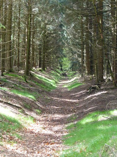
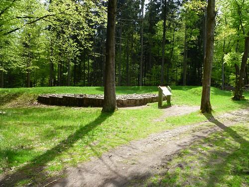
On we go, along the valley that once housed a thriving glass-making industry in the 15th and 16th centuries, and then up, up, up to Rotes Kreuz, a pass through the Taunus for a medieval (and probably earlier) road through the Limes. Soon after we came across the remains of Kastell Feldberg, beautifully presented, were it not for the small tractor cutting (perhaps massacring would be a better word) the grass in the pouring rain. With sundry internal buildings, including an apsidal principia sacellum, and four single-portal gateways, as well as an external bath-house, it is well worth a visit. We carried on climbing gently, before descending to Sandplacken for lunch; a fine stretch of bank and ditch can be seen here, as can WT 3/54 perched precariously on the roadside verge. Remarkably, that busy old fool, the unruly sun, had begun to put in occasional appearances.

The ditch and bank near Sandplacken

After lunch we headed off once more, taking in the remains of a rather hirsute Kleinkastell Altes Jagdhaus (which, unsurprisingly, had the remains of an old hunting lodge inside it) and a contrastingly manicured Kleinkastell Heidenstock before we began a long, 3km descent to Saalburg. The sun, thankfully, was out as we arrived at the end of our 105-mile odyssey.

Kleinkastell Heidenstock

Saalburg itself looked better than when I last saw it, freed of the renovators’ scaffolding and decidedly spruced up. The only down side was that construction work in the fabrica (oh, the irony!) meant it was not accessible. The intermittent rain showed off the eavesdrips to advantage, whilst the principia cross-hall was, as ever, breathtaking. We ate in the taberna before taking our leave of Saalburg and the Obergermanische-Raetische Limes … for the time being.

Statue of Antoninus Pius at Saalburg

86. Who provided the first detailed accounts of Hadrian’s Wall?

178618629_8475244f91Many cite Bede as the supplier of our first account of the remains of Hadrian’s Wall, but he does not go into any great detail. A long succession of antiquarians visited Hadrian’s Wall from the 16th century onwards, one of the earliest and most prominent being William Camden in 1599, although he used the work of a number of others. He was followed at the beginning of the 18th century by Alexander Gordon and John Horsley, as well as William Stukeley and Roger Gale, the second following the first (and to some extent borrowing from him), and the third and fourth travelling together. Horsley’s text was subsequently plagiarised (it is difficult to think of a more polite way of putting it) by John Warburton, whose map – drawn up by one Nathaniel Hill – also bore a striking resemblance to the survey undertaken shortly beforehand for the Military Road. That same survey demonstrated an unusual fascination with the Roman Wall, fortuitously including an elevation drawing of a length of it (since it was subsequently destroyed by the road itself) and a plan of its main features.

Further reading: Birley 1961; Shannon 2007

ORL Day Eight: Kastell Zugmantel to Kleinkastell Meisel

The fort at Zugmantel, so important in Roman frontier studies in so many ways, is frankly a mess. Caged behind wire mesh, entering its compound is not exactly a path to enlightenment. The north and west ramparts can be made out, as can the location of the north gate, but the rest is so overgrown (it is, of course, in woodland) and riddled with unbackfilled excavation trenches that making sense of it is not on the cards.

Zugmantel rampart

It is easier to understand the amphitheatre, which is the only visible part of the substantial civil settlement, and which lies half way between the fort and the Limes, where the reconstructed tower and palisade may be seen.

Zugmantel amphitheatre

After admiring Zugmantel, we set out along the line of the frontier (the bank survives up to 2m high along here), aiming for a lunchtime stop at Dasbach. We followed the frontier above the village of Eschenhahn, but whilst the Limes was free to plough straight on, we had to zigzag downhill, passing through Eschenhahn, before climbing up out of the valley of the Auroffer Bach, and then descending into the valley of the Worsbach, crossing under an Autobahn (the E35) and a railway and over another railway. We rejoined the line of the frontier just before yet another reconstructed tower (WT 3/26) just south of Dasbach.

WT 3/26

Following lunch, we started climbing again, but this time we took advantage of a frontier BOGOF deal, because the Limes was split between an older (hinterer) and newer (vorderer) course, both of which are upstanding.

Junction of the Vorderer and Hinterer Limes

The two frontiers reunited before WT 3/29 and carried on in a straight line to near Kastell Alteburg, where an ancient open-market continues to be held. As the Limes strode directly over the Totenberg, we were forced to take a much less direct route until we at last rejoined it at the site of WT 3/36. Then we had a more-or-less straight run uphill to Kleinkastell Meisel.

Kleinkastell Meisel

85. What is the best bit of Hadrian’s Wall to see?

150511519_c6be927c5e‘Best’ needs to be qualified here: does this mean highest standing, or most carefully finished, or perhaps the most dramatically situated, or the most photographed, or even the bit that can be walked upon? The highest standing sections are at Thorny Doors (NY 722 668), some 500m east of Milecastle 42 (Cawfields), and at Hare Hill (NY 563 646), although the first (3m high) is on a steep incline and the second (2.7m high) had its facing stones reconstructed in the 19th century. A good example of a section that is both carefully finished and dramatically situated is the length of curtain wall at Walltown Crags (NY 672 662). The most photographed section is probably at Cuddy’s Crags looking towards Housesteads Plantation (NY 783 687). The only length where walkers are now permitted on the curtain wall is at Housesteads Plantation (NY 787 687), west of the fort at Housesteads.

Further reading: Burton 2003