Wall Mile 38 [HB 255–7]
To the south of us, now, between the wall and the Military Road, are the remains of the Milking Gap settlement, a nucleated cluster of hut circles and enclosures that may have housed an extended pre-Hadrianic family of farmers (pottery from the site dated to the late 1st and early 2nd centuries AD). Although nothing is visible except from the air, it serves as a reminder that the Roman army were not the only inhabitants around here and how the Wall changed the use of the landscape once and for all and still has an effect today.

Milecastle 38, Hot Bank farm, and the angle in the curtain wall course
The modern stone wall is on top of the remains of the Roman wall immediately to the north of us. The course of the wall swings abruptly onto a more easterly course and we arrive at a kissing gate. Crossing the road leading to Hot Bank farm, we switch to the north of the wall and approach the plantation that clings to the slopes south of Crag Lough (pronounced ‘luff’). Just as the gaps and nicks through the Whin Sill were formed by glacial meltwater breaching the dolerite ridge, so the three prominent lakes north of the Wall (Crag, Broomlee, and Greenlee Loughs) are basins formed by the remnants of that same trapped meltwater. To our right, the ditch, inserted across Milking Gap between Milecastle 38 to Turret 38a to counter the absence of the defensive value of the crags along here, terminates. The gap was too broad to need a re-entrant.
Sufferers of vertigo would now be well advised to detour slightly south onto the Military Way, also a right of way and still clearly visible for the most part as that grassy strip.
To our right we can see Crag Lough (pronounced ‘luff’) and, as we enter a plantation, the path (and the wall immediately south of us) begin to ascend back onto Highshield Crags. Take the time to study the stones used in the field boundary to your left, since these are of course Roman stones reused. By now you are familiar with the size and shape of the regular facing blocks, but you may also be able to recognise narrower string course blocks, incorporated by the more recent drystone wallers. Along the central sector, the National Park maintains an impressive programme of recording and restoring these original stone dykes.

Crag Lough from the Wall
Once at the top, we leave the plantation and a series of impressive clefts shows how precipitous this part of the crags is. As the consolidated curtain wall returns, we start to descend the winding stairs, pausing only to admire the north face of that consolidated curtain wall as we go. We have entered the iconic Sycamore Gap. Unusually, the curtain wall incorporates some blocks of dolerite in the facing of the footings. Notice how some of the curtain is carefully levelled whilst other portions follow the slope. At the bottom, the path turns to cross the wall. Here we are able to see the dark and now shiny dolerite blocks incorporated in the core of the structure as we transit the monument.

Sycamore Gap and Mons Fabricius behind it
The eponymous tree is rooted amongst the fabric of the collapsed curtain wall. Its future has been ensured by planting a replacement slightly to the south within a circular drystone enclosure (called a stell; this is where it was originally situated when Jessie Mothersole walked past in 1921, so the new one is third generation; there was no tree here in 1907, when Maria Hoyer visited). This is the ultimate insurance against the day the main tree gives up the arboreal ghost and relieves the curtain wall of its burden. It is sometimes known as ‘the Robin Hood tree’, not through any folkloric association with that legendary character, but rather because it featured in the 1991 film Robin Hood: Prince of Thieves during a journey supposedly undertaken by the eponymous hero from Dover to Nottingham!
We now have to climb the steps of the small hill known as Mons Fabricius, a name it gained in honour of the German scholar Ernst Fabricius, who visited the frontier in 1928 whilst in Britain to receive an honorary doctorate from the University of Durham. A leading light in the study of the Roman frontiers in Germany (the Upper German and Raetian frontier or Obergermanische-Raetische Limes), his is the singular honour of being the only scholar with a piece of the Wall landscape named after him.

The broad gauge foundation (left), the Narrow Wall (right), and shielings (top left) on Mons Fabricius
On top of the hill, the curtain wall abruptly turns onto a more northerly course to follow the edge of the crags. Amongst the grass on the peak, to the left of the path and at about waist height, there is a row of stones that are in fact the broad gauge foundation, set slightly back from the built line of the Wall. Yet again, we see evidence of pragmatic adaptation during construction of the frontier. Moving a bit further on, tucked up against the south face of the curtain wall to our right, there are some medieval shielings, or shepherd’s shelters.
Now, ahead of us, we are treated to the spectacle of Castle Nick and its milecastle.
Milecastle 39 (Castle Nick) [HB 257–8; haiku]
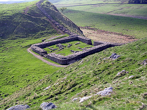
Milecastle 39 in Castle Nickl
The remains of the milecastle originally gave their name to the gap, which has in turn given them back to the milecastle (once scholars got around to numbering and naming them); I hope that’s clear. The surrounding walls of this long-axis milecastle are Claytonized and it has been the object of the attentions of excavators in 1854, between 1908 and 1911, and most recently in the 1980s. The structures visible inside it are for the most part post-medieval (it is said to have been used as a milking parlour) and demonstrate again the re-use of milecastles for agricultural purposes in later years, a theme to which we shall return. It was not located in its measured position but further east, perhaps deliberately to place it in the gap.
